
Use the identify tool to find out more information about a specific feature on the map.
Tohihia ngā āhua ā-mapi i GeoMaps Identify map features in GeoMaps
Identify a parcel of land
Step 1: Click on the Identify button on the map display.

Step 2: Click on the area of the map you want to identify information (attributes).
Step 3: Results for the property layer will be displayed in the results panel. Click on the row you are interested in. If the list of attributes are longer than the results box, then scroll down or resize the widget window to view all.
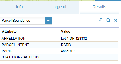
Step 4: To view the parcel attributes, select the Parcel Boundaries layer from the results panel drop down box.
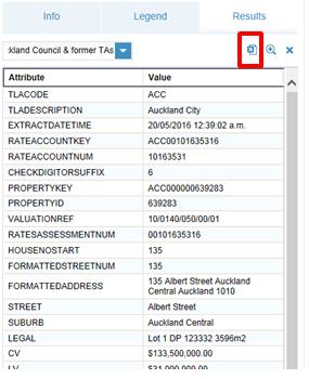
Step 5: Select the layer you want to see the results from in the results panel layer list. If you are not zoomed in very close then you will get many features listed in the result list.
Step 6: To copy/export information to word or excel, click the Export button on the results panel and follow the instructions to save the file.
Step 7: To clear results from the map and the results view, click the ‘X’ button on the right of results panel.